Wednesday, January 29, 2014

Arctic Heat Wave Sets off Hottest Ever Winter-Time Temperatures, Major Melt, Disasters for Coastal and Interior Alaska

Major melt in the midst of winter. Doesn’t sound quite right, does it? We tend to think of winter as the time of freezing, as the time of ice accumulation. Not the time of melt and thaw.

Now try this — major melt in Alaska in the midst of winter. Average temperatures 40 degrees hotter than normal in the midst of winter. Rainfall over snow and ice causing avalanches, major road blockages and ice dams to rivers in the midst of winter.

In this instance we have been transported from the somewhat odd into a reality that is completely outside of our previously ‘normal’ context. In this instance we are transported to a time that may well seem like the beginning of the end of the age of ice on planet Earth.

And yet this is exactly what is happening: one of the coldest regions on the planet is experiencing melt and related record heat in January.

For the state of Alaska, the consequences are a strange and freakish winter heat wave, one that features the extreme temperatures mentioned above. For the city of Valdez, as we shall see below, the situation is far more stark.

(Massive Avalanche set off by rainfall, winter warmth, cutting off Richardson Highway to Valdez Alaska and forming a dangerous ice dam of the ironically named Keystone Canyon’s Lowe River. Image source: Alaska Department of Transportation and Public Facilities.)

Hottest ever Winter-time Temperatures for Alaska

On Sunday, a collapse event that flooded the Arctic with heat and ripped the polar vortex in half began. A freakish high amplitude ridge in the Jet Stream that had been pumping warmth over Alaska and into the Arctic for ten months running strengthened. The result was that many regions throughout the state experienced their hottest temperatures ever recorded for that day, month, or season.

According to reports from Weather Underground, Homer Alaska, for example, experienced an all time record high for the day of 55 degrees Fahrenheit, 4 degrees hotter than the previous all-time high set just a few years earlier. And Homer was just one of the many cities sitting in a broad region of extraordinary, 40 degree hotter than normal temperatures. A region extending from the interior to the southern and western coasts. Bolio Lake Range, about 100 miles south of Fairbanks in central Alaska, saw temperatures rocket to 60 degrees, just 2 degrees short of the all-time record high for any part of the state during January (the previous record high of 62 was set in Petersburg, nearly 700 miles to the south and east).

Typically colder high mountain regions also experienced record warmth for the day. A zone 10,600 feet above Fairbanks hit 32 degrees Fahrenheit on Sunday, the highest temperature ever measured for this region during any winter-time period from November through February.

Even before the most recent extreme Arctic temperature spike, January saw numerous powerful heat influxes for Alaska with Nome, Denali Park, Palmer, Homer, Alyseka, Seward, and Talkeetna each setting all-time record high temperatures during the month.

These records come on the back of a long period of rapidly increasing Alaskan heat stretching all the way back to the 1970s. In many cases, we are seeing all-time record highs broken with 5-10 year frequency. In the most extreme cases, these records fall again after only standing for 1-5 years.

Taken in this context, what we are seeing is the freakish continuation of an ongoing period of inexorable Arctic warming providing yet one more major insult to the Alaskan climate during the winter of 2013-2014.

Rain and Melt Sets off Major, Spring-like, Outflows From Streams and Rivers

The same anomalous Jet Stream pattern that has acted as a conveyer belt continuously transporting heat into the high north over Alaska has brought with it an almost endless series of rain events to coastal Alaska. Storm after storm, fueled by heat and high rates of evaporation over the northern Pacific, slammed into the Alaskan coastline, disgorging record levels of precipitation.

With temperatures freakishly high, mirroring conditions typically present during late spring or early summer, much of this precipitation fell in the form of rain. Valdez, Alaska, for example, has likely experienced its wettest January ever with rainfall measures just 1.35 inches short of the record on Sunday and a series of strong storms rushing into the city on Monday and Tuesday. Given the nearly endless train of storms lining up to sweep over Valdez, it is possible that its previous record of 15.18 inches for January could easily be surpassed by an inch or two at month-end.

The storms and cloudiness make it difficult to peer down and get a good view of what all this heat and rainfall is doing to the Alaskan snow and ice pack. But, for brief respite, on January 25th, just ahead of the most recent influx of rain and warmth, the clouds cleared, revealing the land and sea surface. And what we witness is extraordinary: More


Tuesday, January 28, 2014

Rare snow, ice storm sends shock throughout Deep South

ATLANTA — A Midwest winter storm roared into the the Deep South on Tuesday, bringing icy rain and sleet to South Texas and threats of a dangerous ice storm and power outages from Louisiana to the Virginia coast.

At the same time, intense cold continued its onslaught across the north-central and northeastern U.S., with wind chill warnings and advisories in place all the way from Montana to Maine.

In the South, snow fell on Alabama-Georgia border Tuesday morning, moving quickly into northwest Atlanta suburbs. Forecasts called for up to a foot of snow in Virginia Beach, Norfolk, Portsmouth and Chesapeake in Virginia and up to 10 inches along much of the North Carolina coast.

Delta Airlines, with headquarters in Atlanta, said 1,850 flights have been canceled systemwide Tuesday beginning at 11 a.m. ET. Of that number, 840 flights from Atlanta were affected.

In the Atlanta area, which was bracing for up to 2 inches of snow, several school systems canceled classes or announced early closings.

“We have preparations from a couple of other close calls the past few weeks,” said Mark McKinnon, a spokesman for the Georgia Department of Transportation. “They’ve just got to come in and crank it up.”

He said crews would likely come in at noon Tuesday and begin pretreating bridges with a salt-brine mixture, and then be on call to battle snow and ice with salt and pea-sized gravel.

The threat of icy roads was particularly alarming in southern cities unequipped for such rare weather, including Austin, Charleston, S.C., Pensacola, Fla., Mobile, Ala., and New Orleans.

“This is a very dangerous situation because snow and ice are very rare for extreme southern Mississippi,” said Robert Latham, executive director of the Mississippi Emergency Management Agency. “We need everyone to have an emergency plan together for this.”

Louisiana Gov. Bobby Jindal declared a state of emergency in the Pelican State because of the threat of heavy snow plus freezing temperatures that could paralyze most roadways.

“It’s important people start preparing now for the storm,” Jindal said late Monday. “We are working to keep open major corridors across the state, but only for those who absolutely must travel.”

In Columbia, S.C., Fort Jackson planned to stop normal operation at mid-morning and keep on only essential personnel.

In Savannah, which is expecting a wintry mix of snow and freezing rain, schools have been closed and residents were “making a run” on grocery stores, said Bret Bell, a city spokesman. He said the main concern was not so much snow as icing on roads.

Appalachian Power asked its customers in Tennessee, Virginia and West Virginia to conserve electricity and minimize the threat of power disruptions during the cold snap.

The utility says PJM Interconnection, which operates the electricity grid for 13 states and the District of Columbia, has issued a call for voluntary conservation on Tuesday because of expected high demand.

The harsh cold pushing into the South is an extension of the hard freeze that has gripped the Midwest for days. Schools in Chicago are closed for a second day.

In Minnesota, most metro schools and the University of Minnesota are closed as wind chills were expected to drop as low as 35 to 50 degrees below zero.

The state was also struggling with a short supply of natural gas in some parts due to a Canadian pipeline explosion.

Xcel Energy asked all customers, including in the Twin Cities, to cut back on natural gas use and hold their home thermostats at 60 degrees. More


Friday, January 24, 2014

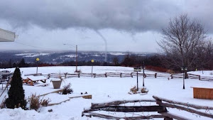
Waterspouts in Winter? Yes, It Happened This Week and We Have the Proof!

When you hear the term waterspout, you may think of places like the Florida Keys or Gulf Coast in summer. If you live around the Great Lakes, you may have seen one in the fall.

But what about the dead of winter in the northern U.S.? It's not just theoretically possible, it actually happened twice this week.

The photo above was taken in the Finger Lakes region of central New York, specifically Cayuga Lake, on the morning of January 21. The morning low temperature in nearby Ithaca, N.Y. was 5 degrees, so it's conceivable temperatures at the time of the photo were no warmer than the single digits or teens.

A second waterspout was photographed on the southern end of Lake Champlain near Essex, N.Y. on the afternoon of January 22.

The daytime high in nearby Burlington, Vt. was two degrees below zero.

Isn't it too cold for this in January? Doesn't it have to be at least somewhat warm and humid?

The key to waterspouts forming is not simply the surface temperature, but the temperature difference between air near the lake surface and air a few thousand feet above the surface.

When deep, cold air spills over relatively warm bodies of water, such as the Great Lakes, Lake Champlain, or Cayuga Lake, the difference between the cold air aloft and the not as cold air near the lake surface leads to instability, namely, air that wants to rise, forming clouds. This is the basic mechanism for lake-effect rain and snow.

If there's enough low-level spin from a weak wind shift boundary over the body of water, the rising air converging from different directions can tighten the rotation into a waterspout.

In both cases from this past week, it appears the waterspouts formed from within a lake-effect snowband.

Of course, for this to occur in mid-winter, you also need a relatively ice-free body of water, otherwise the flux of relatively warm, humid air from the lake, or river won't occur.

Winter waterspouts were also photographed in early January 2012 over the Missouri River in South Dakota. According to photographer Chris Westcott, there were six brief waterspouts at one time during this event.

Most fair-weather, or non-supercell, waterspouts remain over water. Those that do come ashore are usually capable of only minor damage, with maximum wind speeds generally under 70 mph.

It has been estimated between 400 and 500 waterspouts spin near the Florida Keys each year. More


Sunday, January 19, 2014

Farmers worldwide suffer as extreme weather wreaks food havoc

To address the crisis, farm ministers from around the world are gathering in Berlin Saturday to discuss climate change and food production.

BOSTON — Volatile weather around the world is taking farmers on a wild ride. Too much rain in northern China damaged crops in May, three years after too little rain turned the world’s second-biggest corn producer into a net importer of the grain. Dry weather in the U.S. will cut beef output from the world’s biggest producer to the lowest level since 1994, following 2013’s bumper corn crop, which pushed America’s inventory up 30 percent. British farmers couldn’t plant in muddy fields after the second-wettest year on record in 2012 dented the nation’s wheat production.

“Extreme weather events are a massive risk to agriculture,” said Peter Kendall, president of the British National Farmers Union, who raises 3,953 acres of grain crops in Bedfordshire, England. “Farmers can adapt to gradual temperature increases, but extreme weather events have the potential to completely undermine production. It could be drought, it could be too much rain, it could be extreme heat at the wrong time. It’s the extreme that does the damage.”

Farm ministers from around the world are gathering in Berlin Saturday to discuss climate change and food production at an annual agricultural forum, with a joint statement planned after the meeting.

Fast-changing weather patterns, such as the invasion of Arctic air that pushed the mercury in New York from an unseasonably warm 55 degrees Fahrenheit on Jan. 6 to a record low of 4 the next day, will only become more commonplace, according to the New York-based Insurance Information Institute. While the world produces enough to provide its 7 billion people with roughly 2,700 calories daily, and hunger across the globe is declining, one in eight people still don’t get enough to eat, some of which can be blamed on drought, the United Nations said.

“There’s no question, while there’s variability and volatility from year to year, the number and the cost of catastrophic weather events is on the rise, not just in the U.S., but on a global scale,” said Robert Hartwig, an economist and president of the insurance institute. “It’s all but certain that the size and the magnitude and the frequency of disaster losses in the future is going to be larger than what we see today.”

The number of weather events and earthquakes resulting in insured losses climbed last year to 880, 40 percent higher than the average of the last 30 years, according to Munich Re, the world’s largest reinsurer.

Research points to a culprit: an increase in greenhouse gases, generated by human activity, that are forcing global temperatures upward, said Thomas Peterson, principal scientist at the U.S. National Climatic Data Center in Asheville, N.C. The warmer the air the more water it can hold, he said.

“What we’re finding worldwide is that heavy precipitation is increasing,” Peterson said.

Flood waters in Passau, Germany, in May and June reached the highest level since 1501, Munich Re said. That was the year Michelangelo first put a chisel to the block of marble that would become his sculpture of David. High water did $15.2 billion in damage in parts of Central and Eastern Europe, according to Munich Re.

A July hailstorm in Reutlingen, Germany, led to $3.7 billion in insured losses, according to Munich Re. Hailstones the size of babies’ fists cracked the windshield of Marco Kaschuba’s Peugeot.

“Two minutes before the storm started you could already hear a very loud noise,” said Kaschuba, a 33-year-old photographer. “That was from hailstones hitting the ground in the distance and coming closer.”

In 2012, Britain had its second-highest rainfall going back to 1910, according to Britain’s meteorology office. England and Wales had its third-wettest year since 1766. More


Sunday, January 5, 2014

Record-breaking cold possible across two-thirds of U.S.

The National Weather Service warned Sunday that much of the United States will see this week the coldest temperatures in almost 20 years as an arctic cold front descends on 140 million people

"A piece of a polar vortex, the coldest air in the Northern Hemisphere ... is coming," CNN Meteorologist Alexandra Steele said.

And in addition to the cold, there will be heavy snow in the eastern Plains and Great Lakes, as much as a foot Sunday.

Temperatures will be 30 to 50 degrees below average Sunday from the Plains to the Upper Mississippi Valley, forecasters said.

By Wednesday, nearly half the nation will shudder in temperatures of zero or lower, forecasters said. Even the Deep South will endure single-digit or sub-zero temperatures.

Sunday's weather will have a huge impact on travel, with more than 1,700 flights originating in or heading to the U.S. canceled, according to flight-tracking website flightaware.com.

John F. Kennedy International Airport in New York was closed as of 8:30 a.m. ET. after an incident involving a regional jet, Delta Flight 4100 from Toronto.

Port Authority spokesman Ron Marsico said the plane, carrying 35 persons, skidded into a snow bank while turning onto a taxiway after landing safely. No injuries are reported. Port Authority police and emergency crews were assisting passengers

The airport wasn't expected to reopen for a few hours, the Federal Aviation Administration said.

There were flight arrival delays at Philadelphia International Airport because of the weather. Arriving flights were delayed an average of two hours and 48 minutes.

Here's what to expect across the country:

The central U.S. ... and one freakishly cold game

More than 70,000 hardcore Green Bay Packers fans hoping to see their team get closer to the Super Bowl will have their loyalty tested Sunday as they endure temperatures between 4 and 8 degrees in Wisconsin. With the wind, the air could feel as cold as minus 15 degrees to the sold-out crowd.

Dr. Sanjay Gupta: Packers fans could suffer hypothermia or frostbite

The Packers will give free hand warmers, hot chocolate and coffee at the game, which is scheduled to begin at 4:40 p.m ET, spokesman Aaron Popkey said.

Packers running back Eddie Lacy said he didn't think there was much he could do to prepare for a game this cold.

"It's definitely going to be a different experience," he said Saturday, according to the team website. "It's mind over matter."

And it'll get worse, overnight temperatures are expected to fall to minus 15 degrees.

In Embarrass, Minnesota, residents wondered whether they might see their record-cold temperature of 64 below zero, set in 1996, snap like an icicle.

"I've got a thermometer from the weather service that goes to 100 below," resident Roland Fowler told CNN affiliate KQDS. "If it gets that cold, I don't want to be here."

The Deep South

The arctic blast threatens to sweep subzero lows as far south as Alabama and plunge much of the Deep South into the single digits.

To put things in perspective, the weather in Atlanta and Nashville, Tennessee on Monday will be colder than in Anchorage, Alaska, Steele said.

Freezing rain is also possible along the Appalachians all the way up to New England over the next couple of days, the National Weather Service said.

Deadly conditions

The low temperatures and wind chill are a dangerous recipe for rapid frostbite or hypothermia.

"Exposed flesh can freeze in as little as five minutes with wind chills colder than 50 below," the National Weather Service's Twin Cities office in Minnesota said.

Over the past week, at least 13 people have died from weather-related conditions.

Eleven people died in road accidents -- including one man crushed as he was moving street salt with a forklift.

One man in Wisconsin died of hypothermia. And an elderly woman with Alzheimer's disease in New York state wandered away from her home and was found dead in the snow in a wooded area about 100 yards away.

Indiana Gov. Mike Pence encouraged residents to do more than check on friends and relatives.

"In preparation for the inclement weather, I encourage Hoosiers to assemble an emergency preparedness kit with plenty of nonperishable food and water, fill any necessary prescriptions, ensure they have a safe heating source, avoid unnecessary travel and be careful if they must be outside." he said.

Travel nightmares

The already dreadful stream of stranded passengers and canceled flights will only get worse.

8 tips to ease winter travel woes

FlightAware.com, which tracks cancellations due to weather, mechanical and other problems, said more than 1,700 flights have been canceled for Sunday. That's after 4,500 flights were called off on Friday and Saturday.

In Chicago, a plane headed to Las Vegas slid off the taxiway at O'Hare International Airport on Saturday night. None of the passengers on Spirit Flight 245 were injured, an airlines spokeswoman said.

But with the Windy City inundated by snow, O'Hare will have more troubles Sunday. About 1,000 inbound or outbound flights have already been canceled, according to FlightAware.com.

Other cities like Cincinnati; Lexington, Kentucky; Louisville, Kentucky; and Memphis will see temperatures crash Sunday, and precipitation could lead to dangerous, icy driving conditions.

Roads will worsen Sunday night in Atlanta; Birmingham, Alabama; and Knoxville, Tennessee, forecasters said. More


Wednesday, January 1, 2014

Climate Change Worse Than We Thought, Likely To Be 'Catastrophic Rather Than Simply Dangerous'

Climate change may be far worse than scientists thought, causing global temperatures to rise by at least 4 degrees Celsius by 2100, or about 7.2 degrees Fahrenheit, according to a new study.

The study, published in the journal Nature, takes a fresh look at clouds' effect on the planet, according to a report by The Guardian. The research found that as the planet heats, fewer sunlight-reflecting clouds form, causing temperatures to rise further in an upward spiral.

That number is double what many governments agree is the threshold for dangerous warming. Aside from dramatic environmental shifts like melting sea ice, many of the ills of the modern world -- starvation, poverty, war and disease -- are likely to get worse as the planet warms.

"4C would likely be catastrophic rather than simply dangerous," lead researcher Steven Sherwood told the Guardian. "For example, it would make life difficult, if not impossible, in much of the tropics, and would guarantee the eventual melting of the Greenland ice sheet and some of the Antarctic ice sheet."

Another report released earlier this month said the abrupt changes caused by rapid warming should be cause for concern, as many of climate change's biggest threats are those we aren't ready for.

In September, the Intergovernmental Panel on Climate Change said it was "extremely likely" that human activity was the dominant cause of global warming, or about 95 percent certain -- often the gold standard in scientific accuracy.

"If this isn't an alarm bell, then I don't know what one is. If ever there were an issue that demanded greater cooperation, partnership, and committed diplomacy, this is it," U.S. Secretary of State John Kerry said after the IPCC report was released. More